Synopsis
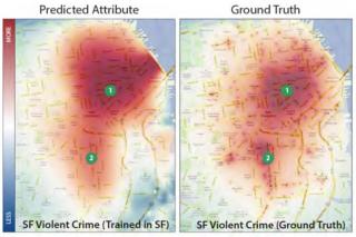
A modern city is a massive and ceaseless information producer, constantly generating thousands of disparate pieces of localized information (e.g. housing prices, restaurant health inspection scores, crime statistics, precipitation levels, building code violations, water usage, etc.). We seek to use computer vision techniques trained on massive amounts of readily-available visual data such as streetview images to understand non-visual abstract attributes like housing prices or perceptions of safety.
Project Details
Non-UCSD Vision People also Involved
Details
A modern city is a massive and ceaseless information producer, constantly generating thousands of disparate pieces of localized information (e.g. housing prices, restaurant health inspection scores, crime statistics, precipitation levels, building code violations, water usage, etc.). Since each such city attribute is associated with a location (latitude, longitude) we typically visualize them as attribute maps. While such maps have long been used to analyze and understand cities, urban planners have recently started applying big data analysis and mining techniques to identify meaningful correlations between these mapped attributes (so called "correlation mining"). In contrast to the urban planning and data mining communities, we seek to understand how visual appearance is related to non-visual attributes. With the widespread availability of street-level imagery (Google StreetView, Bing Streetside, etc.) we now have the data necessary to identify and validate such predictive relationships.
